Cordillera de Talamanca
Paragraph
Cordillera de Talamanca is a mountain range located in Southern Costa Rica and crosses into Panama. It’s surrounded by the Caribbean Sea and the Pacific Ocean and is home to the highest mountain in Costa Rica, Mount Chirripó (3,819m). Talamanca has beautiful mountains and foothills that contain Quaternary glaciation like Glacial cirques, Lakes and valleys, and phenomena. It is covered with rivers and creeks that are found all over the range, especially the ones that have turned into waterfalls. Cordillera de Talamanca is also home to thousands of plants, with some being non-vascular, meaning they are smaller and less complex, and the rest being flowering plants which are more complex. Surrounding the plants are nearly 1,000 fern species, meaning they reproduce via spores and don’t have seeds or flowers, as well as 900 species of lichen, which are species that have relationships between fungus and an alga or a cyanobacterium. The mountain range varies depending on the elevation. In the higher mountains, the climate is usually rainfall with cool temperatures frosting on top of the mountains at points making the temperatures a lot cooler. The high mountains have Central America’s record for lowest temperature which is sixteen degrees Fahrenheit. Towards the bottom of the mountain range is a more tropical climate with clear wet and dry seasons making the temperatures nearly eighty degrees Fahrenheit. Overall, the Cordillera de Talamanca is a beautiful and common tourist spot for people to learn about some of the history and geographical features that make up Costa Rica.
Pictures

Baird's Tapir is a tapir species that is found in the northwestern part of the Cordillera de Talamanca.
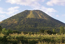
Volcan Barú is a stratovolcano that is active and is found in the western part of Panama.
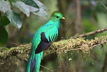
Resplendent Quetzal is a small bird that is found in a cloud forest within the mountain range.
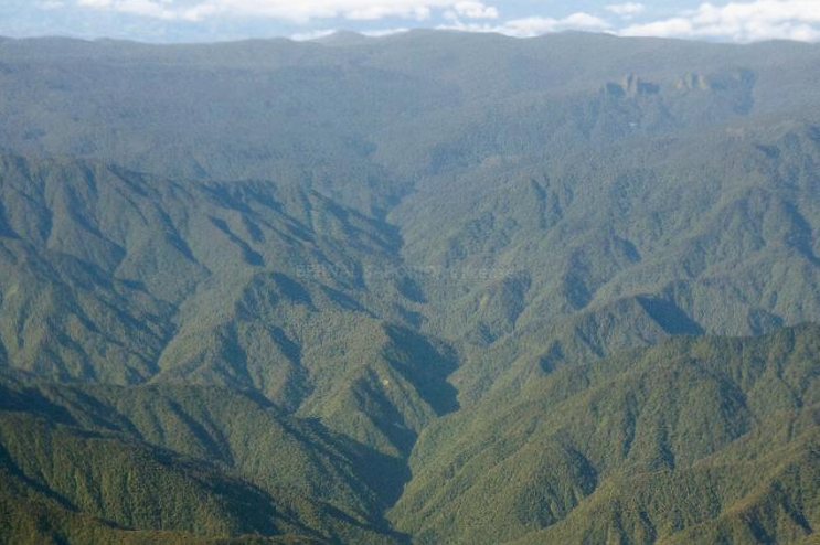
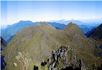
Cerro de Terbi is a mountain located in the Chirripó National Park, which is located in southern Costa Rica.
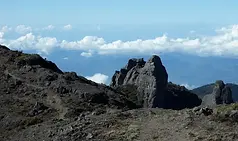
Cerro Chirripó is the highest mountain in Costa Rica and is located in the Chirripó National Park.
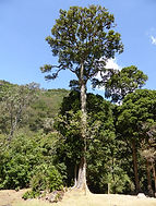
The Quercus copeyensis is an oak tree found in the Talamancan forest along the northwestern side of the Cordillera de Talamanca.
Citations
Garin, Paco. “Quercus Copeyensis.” Flickr, 9 Mar. 2025, www.flickr.com/photos/helicongus/albums/72157635499250980/. Accessed 9 Mar. 2025.
Gómez, Juan. “Volcán Barú National Park.” Global National Parks, 22 June 2023, www.globalnationalparks.com/panama/volcan-baru/. Accessed 9 Mar. 2025.
to, Contributors. “Mountain in Costa Rica.” Wikipedia.org, Wikimedia Foundation, Inc., 29 Nov. 2004, en.wikipedia.org/wiki/Cerro_Chirrip%C3%B3. Accessed 9 Mar. 2025.
to, Contributors. “Species of Bird.” Wikipedia.org, Wikimedia Foundation, Inc., 24 Dec. 2004, en.wikipedia.org/wiki/Resplendent_quetzal. Accessed 9 Mar. 2025.
World, UNESCO. “Talamanca Range-La Amistad Reserves / La Amistad National Park.” Unesco.org, 2018, whc.unesco.org/en/list/205. Accessed 9 Feb. 2025.
“Cerro Terbi 3,760m, Chirripo, Costa Rica.” Komoot, 2020, www.komoot.com/highlight/2857763. Accessed 9 Mar. 2025.
“Cordillera de Talamanca: Biodiverse Haven in Central America | LAC Geo.” Lacgeo.com, 3 Sept. 2024, lacgeo.com/cordillera-talamanca-mountain-range. Accessed 9 Mar. 2025.
“Why the Baird’s Tapir Is Known as a “Living Fossil” | One Earth.” One Earth, oneearth.org, 23 Feb. 2024, www.oneearth.org/species-of-the-week-bairds-tapir/. Accessed 9 Mar. 2025.